The following four images were created from the same MultiFAX "raw" image file as captured directly from a NOAA weather satellite. The NOAA satellites are in low Earth polar orbits approximately 550 miles in altitude. This orbit configuration means that every spot on Earth is covered at least twice a day and, becuase of overlap on consecutive orbits, most locations can receive from 4 to 6 image transmissions in one 24 hour period from each satellite.
To get the full effect of the high resolution provided by the NOAA weather satellites please view the high resolution versions available for each of the "thumbnail" images below. Return to home page.
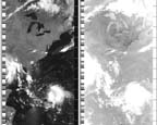
This image is a very reduced representation of the complete NOAA image
received at the satellite ground station. The image covers approximately 3000
miles in height (north-south) and about 1800 miles in width (east-west). Note
that there are 2 images--the one on the left is a visual image taken in normal
visible light and the image on the right is taken in IR. The gray scale in the
IR image represents temperature (dark is warm, light is cold). The MultiFAX
software can measure accurate temperature directly from the IR image using the
mouse pointer. You can just make out the Great Lakes, the east US coast, and
Florida in the visible light image. Click image for higher resolution (58KB).
 This image is a 2X zoom or magnification of the one above. The area zoomed is on the visible light
side of the image. The Great Lakes are clearly visible now and Long Island and Chesapeake bay are
detectable. Each time the MultiFAX software zooms into an image more data is
actually shown in the zoomed area (except at 8X) than in the previous view--it is not just
empty pixel magnification. Click image for higher resolution (53KB).
This image is a 2X zoom or magnification of the one above. The area zoomed is on the visible light
side of the image. The Great Lakes are clearly visible now and Long Island and Chesapeake bay are
detectable. Each time the MultiFAX software zooms into an image more data is
actually shown in the zoomed area (except at 8X) than in the previous view--it is not just
empty pixel magnification. Click image for higher resolution (53KB).
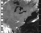
 This is a 4X magnification of the original image. Long Island is
clearly visible and Lake Champlain and the Hudson river valley are now
just becoming detectable. The area of coverage in this image is
approximately 750 miles high by 1000 miles wide. At this point in the
magnification all the data captured by the NOAA satellite in the zoomed area
is being displayed. The NOAA satellites are capable of 2-3 mile resolution.
Click image for higher resolution (41KB).
This is a 4X magnification of the original image. Long Island is
clearly visible and Lake Champlain and the Hudson river valley are now
just becoming detectable. The area of coverage in this image is
approximately 750 miles high by 1000 miles wide. At this point in the
magnification all the data captured by the NOAA satellite in the zoomed area
is being displayed. The NOAA satellites are capable of 2-3 mile resolution.
Click image for higher resolution (41KB).
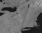 This is an 8X magnification of the original image. If you viewed this image
at full resolution on your computer monitor you would see that the pixels
making up the image are larger than in previous zooms and have a slight "blocky"
appearance. This is because the limit of satellite resolution was reached
in the 4X zoom and at this point the pixels must be magnified along with the
image scale. At the image scale used on this page it appears that more
detail is shown and the Finger Lakes of NY State, Cape Code, Nantucket,
and Martha's Vineyard are clearly visible. Click image for higher resolution (29KB).
This is an 8X magnification of the original image. If you viewed this image
at full resolution on your computer monitor you would see that the pixels
making up the image are larger than in previous zooms and have a slight "blocky"
appearance. This is because the limit of satellite resolution was reached
in the 4X zoom and at this point the pixels must be magnified along with the
image scale. At the image scale used on this page it appears that more
detail is shown and the Finger Lakes of NY State, Cape Code, Nantucket,
and Martha's Vineyard are clearly visible. Click image for higher resolution (29KB).
 Russia also has a number of polar orbiting weather satellites. These Russian
weather satellite images can also be captured with the MultiFAX system.
This image is from a Russian METEOR satellite showing Prince Edward
Island and the Gulf of St. Lawrence in Canada. The Russian satellites
are capable of sending very high detail. Click image for higher
resolution (31KB).
Russia also has a number of polar orbiting weather satellites. These Russian
weather satellite images can also be captured with the MultiFAX system.
This image is from a Russian METEOR satellite showing Prince Edward
Island and the Gulf of St. Lawrence in Canada. The Russian satellites
are capable of sending very high detail. Click image for higher
resolution (31KB).