Atlantic hurricane projected paths
Hurricane Hunters home page
Canadian Hurricane Center main page
Hurricane/Typhoon/Tropical Cyclone FAQ
General hurricane info
TRACK MAPS:
TRACK MAPS:
TRACK MAPS:
TRACK MAPS:
TRACK MAPS:
TRACK MAPS:
TRACK MAPS:
TRACK MAPS:
TRACK MAPS:
TRACK MAPS:
TRACK MAPS:
TRACK MAPS:
TRACK MAPS:
TRACK MAPS:
TRACK MAPS:
TRACK MAPS:
TRACK MAPS:
Tropical Storm ARTHUR:
Experts' predictions were off for 2007: CNN news article
Tropical Storm OLGA:
TRACK MAPS:
elsewhere in November:
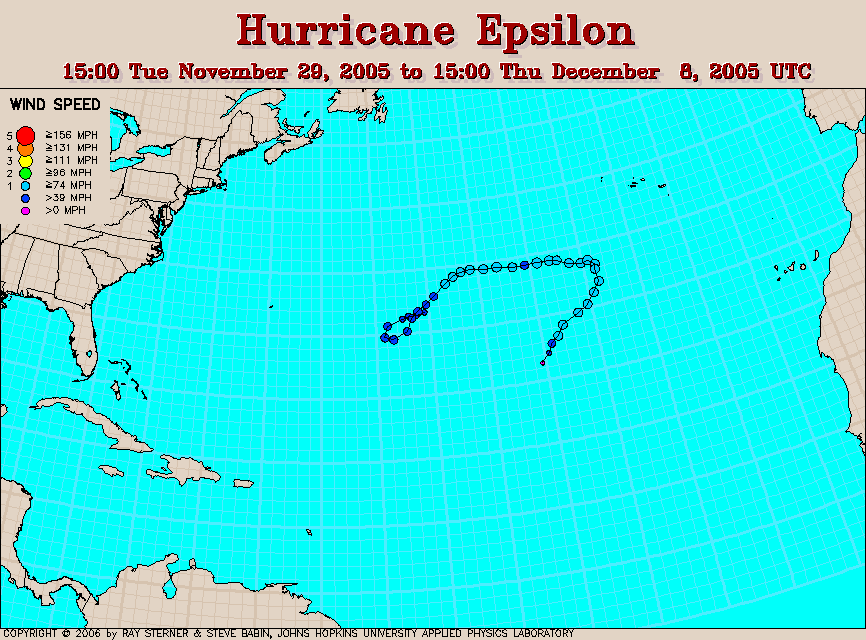
Hurricane EPSILON:
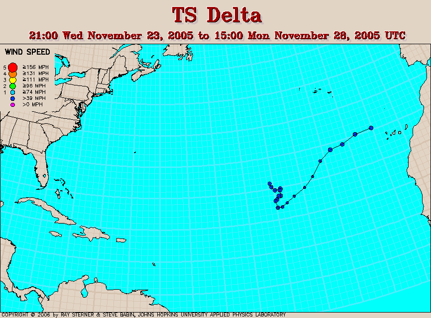
Tropical Storm DELTA:
Tropical Storm GAMMA:
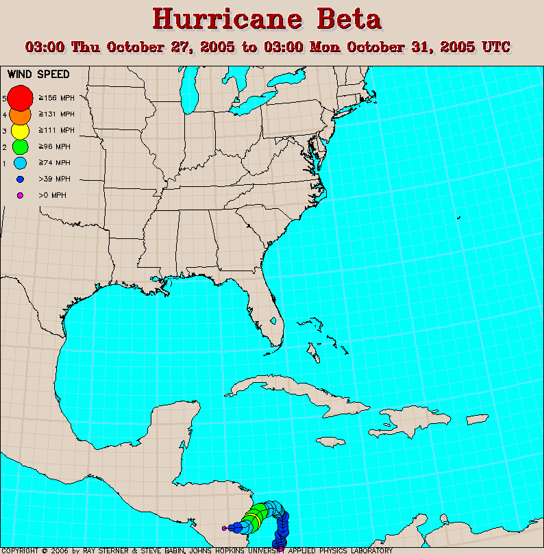
Hurricane BETA:
Tropical Storm ALPHA:
Hurricane WILMA:
TRACK MAPS:
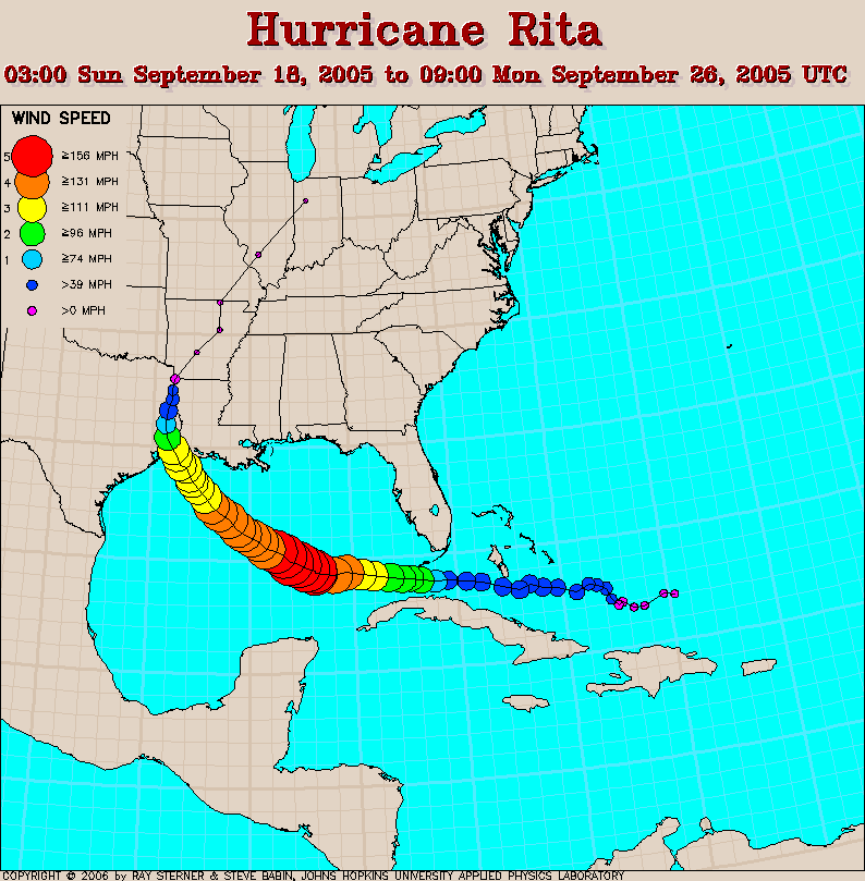
Hurricane RITA:
TRACK MAPS:
Hurricane KATRINA:
TRACK MAPS:
Hurricane DENNIS:
TRACK MAPS:
Hurricane season off to busiest start in history: The Miami Herald news article
elsewhere in January:
The 2004 hurricane season in review
2004 Hurricane Summaries by reknowned hurricane chaser Jim Leonard "Cyclone Jim"
elsewhere in October:
Super Typhoon MA-ON hits Japan
Hurricane IVAN:
Hurricane FRANCES:
track map for Hurricane DANIELLE
Hurricane CHARLEY:
Tropical Storm BONNIE:
track map for Hurricane ALEX
elsewhere in March:
elsewhere in January:
track map for POST SEASON Tropical Storm PETER
track map for POST SEASON Tropical Storm ODETTE
Hurricane JUAN:
Hurricane ISABEL:
Typhoon MAEMI hitting South Korea 13 September 2003: images & video
Hurricane CLAUDETTE hits Texas, weakens to tropical storm: news article
Subtropical Storm ANA takes shape long before the start of Atlantic tropical season (May 15) and becomes second tropical storm ever to form in the month of April:
Read the latest bulletin from the National Hurricane Center...more info here and track map here
Severe Tropical Cyclone ERICA hits New Caledonia: photos and video
Hurricane Zoe hits the Solomon Islands with satellite-estimated wind speeds of 178 mph sustained (200+ mph gusts) in late December 2002. It is one of the strongest hurricanes ever in the Pacific Ocean:
El Ni�o suppresses 2002 hurricanes: NOAA press release
Hurricane KENNA pounds Mexico: news article | images and video
GUSTAV becomes first hurricane of the season
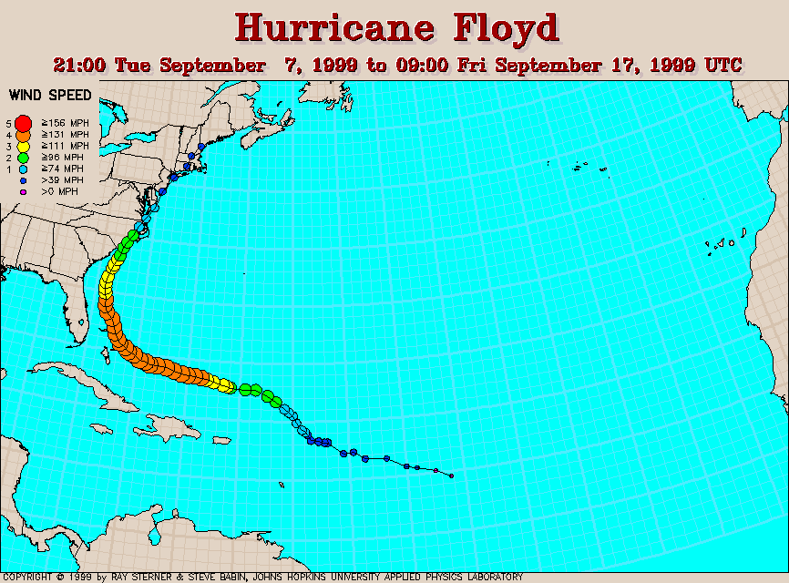
Hurricane FLOYD track map
National Hurricane Center bibliography for Hurricane Andrew
predictions for the 2025 Atlantic hurricane season:
Colorado State University NOAA
2024:
Tropical Storm SARA
Hurricane RAFAEL
Tropical Storm PATTY
Hurricane OSCAR
Tropical Storm NADINE
Hurricane MILTON
Hurricane LESLIE
Hurricane KIRK
Tropical Storm JOYCE
Hurricane ISAAC
Hurricane HELENE
Tropical Storm GORDON
Hurricane FRANCINE
Hurricane ERNESTO
Hurricane DEBBY
Tropical Storm CHRIS
Hurricane BERYL
Tropical Storm ALBERTO
2023:
Hurricane TAMMY
Tropical Storm SEAN
Tropical Storm RINA
Tropical Storm PHILIPPE
Tropical Storm OPHELIA
Hurricane NIGEL
Hurricane MARGOT
Hurricane LEE
Tropical Storm KATIA
Tropical Storm JOSE
Hurricane IDALIA
Tropical Storm HAROLD
Tropical Storm GERT
Hurricane FRANKLIN
Tropical Storm EMILY
Hurricane DON
Tropical Storm CINDY
Tropical Storm BRET
Tropical Storm ARLENE
2022:
Hurricane NICOLE
Hurricane MARTIN
Hurricane LISA
Tropical Storm KARL
Hurricane JULIA
Hurricane IAN
Tropical Storm HERMINE
Tropical Storm GASTON
Hurricane FIONA
Hurricane EARL
Hurricane DANIELLE
Tropical Storm COLIN
Hurricane BONNIE
Tropical Storm ALEX
2021:
Tropical Storm WANDA
Tropical Storm VICTOR
Sub-tropical Storm TERESA
Hurricane SAM
Tropical Storm ROSE
Tropical Storm PETER
Tropical Storm ODETTE
Hurricane NICHOLAS
Tropical Storm MINDY
Hurricane LARRY
Tropical Storm KATE
Tropical Storm JULIAN
Hurricane IDA
Hurricane HENRI
Hurricane GRACE
Tropical Storm FRED
Hurricane ELSA
Tropical Storm DANNY
Tropical Storm CLAUDETTE
Tropical Storm BILL
Tropical Storm ANA
2020:
Hurricane IOTA
Tropical Storm THETA
Hurricane ETA
Hurricane ZETA
Hurricane EPSILON
Hurricane DELTA
Tropical Storm GAMMA
Tropical Storm BETA
Sub-tropical Storm ALPHA
Tropical Storm WILFRED
Tropical Storm VICKY
Hurricane TEDDY
Hurricane SALLY
Tropical Storm RENE
Hurricane PAULETTE
Tropical Storm OMAR
Hurricane NANA
Hurricane MARCO
Hurricane LAURA
Tropical Storm KYLE
Tropical Storm JOSEPHINE
Hurricane ISAIAS
Hurricane HANNA
Tropical Storm GONZALO
Tropical Storm FAY
Tropical Storm EDOUARD
Tropical Storm DOLLY
Tropical Storm CRISTOBAL
Tropical Storm BERTHA
Tropical Storm ARTHUR
2019:
Tropical Storm SEBASTIEN
Subtropical Storm REBEKAH
Hurricane PABLO
Tropical Storm OLGA
Tropical Storm NESTOR
Tropical Storm MELISSA
Hurricane LORENZO
Tropical Storm KAREN
Tropical Storm JERRY
Tropical Storm IMELDA
Hurricane HUMBERTO
Tropical Storm GABRIELLE
Tropical Storm FERNAND
Tropical Storm ERIN
Hurricane DORIAN
Tropical Storm CHANTAL
Hurricane BARRY
Sub-tropical Storm ANDREA
2018:
Hurricane OSCAR
Tropical Storm NADINE
Hurricane MICHAEL
Hurricane LESLIE
Tropical Storm KIRK
Tropical Storm JOYCE
Hurricane ISAAC
Hurricane HELENE
Tropical Storm GORDON
Hurricane FLORENCE
Tropical Storm ERNESTO
Tropical Storm DEBBY
Tropical Storm CHRIS
Hurricane BERYL
Sub-tropical Storm ALBERTO
2017:
Tropical Storm RINA
Tropical Storm PHILIPPE
Hurricane OPHELIA
Hurricane NATE
Hurricane MARIA
Hurricane LEE
Hurricane KATIA
Hurricane JOSE
Hurricane IRMA
Hurricane HARVEY
Hurricane GERT
Hurricane FRANKLIN
Tropical Storm EMILY
Tropical Storm DON
Tropical Storm CINDY
Tropical Storm BRET
Tropical Storm ARLENE
2016:
Hurricane OTTO
Hurricane NICOLE
Hurricane MATTHEW
Tropical Storm LISA
Tropical Storm KARL
Tropical Storm JULIA
Tropical Storm IAN
Hurricane HERMINE
Hurricane GASTON
Tropical Storm FIONA
Tropical Storm EARL
Tropical Storm DANIELLE
Tropical Storm COLIN
Tropical Storm BONNIE
Hurricane ALEX
2015:
Hurricane KATE
Hurricane JOAQUIN
Tropical Storm IDA
Tropical Storm HENRI
Tropical Storm GRACE
Hurricane FRED
Tropical Storm ERIKA
Hurricane DANNY
Tropical Storm CLAUDETTE
Tropical Storm BILL
Tropical Storm ANA
2014:
Tropical Storm HANNA
Hurricane GONZALO
Hurricane FAY
Hurricane EDOUARD
Tropical Storm DOLLY
Hurricane CRISTOBAL
Hurricane BERTHA
Hurricane ARTHUR
2013:
Tropical Storm MELISSA
Tropical Storm LORENZO
Tropical Storm KAREN
Tropical Storm JERRY
Hurricane INGRID
Hurricane HUMBERTO
Tropical Storm GABRIELLE
Tropical Storm FERNAND
Tropical Storm ERIN
Tropical Storm DORIAN
Tropical Storm CHANTAL
Tropical Storm BARRY
Tropical Storm ANDREA
2012:
Tropical Storm TONY
Hurricane SANDY
Hurricane RAFAEL
Tropical Storm PATTY
Tropical Storm OSCAR
Hurricane NADINE
Hurricane MICHAEL
Hurricane LESLIE
Hurricane KIRK
Tropical Storm JOYCE
Hurricane ISAAC
Tropical Storm HELENE
Tropical Storm GORDON
Tropical Storm FLORENCE
Tropical Storm ERNESTO
Tropical Storm DEBBY
Hurricane CHRIS
Tropical Storm BERYL
Tropical Storm ALBERTO
2011:
Tropical Storm SEAN
Hurricane RINA
Hurricane PHILIPPE
Hurricane OPHELIA
Tropical Storm NATE
Hurricane MARIA
Tropical Storm LEE
Hurricane KATIA
Tropical Storm JOSE
Hurricane IRENE
Tropical Storm HARVEY
Tropical Storm GERT
Tropical Storm FRANKLIN
Tropical Storm EMILY
Tropical Storm DON
Tropical Storm CINDY
Tropical Storm BRET
Tropical Storm ARLENE
2010:
Hurricane TOMAS
Hurricane SHARY
Hurricane RICHARD
Hurricane PAULA
Hurricane OTTO
Tropical Storm NICOLE
Tropical Storm MATTHEW
Hurricane LISA
Hurricane KARL
Tropical Storm JULIA
Hurricane IGOR
Tropical Storm HERMINE
Tropical Storm GASTON
Tropical Storm FIONA
Hurricane EARL
Hurricane DANIELLE
Tropical Storm COLIN
Tropical Storm BONNIE
Hurricane ALEX
2009:
Hurricane IDA
Tropical Storm HENRI
Tropical Storm GRACE
Hurricane FRED
Tropical Storm ERIKA
Tropical Storm DANNY
Tropical Storm CLAUDETTE
Hurricane BILL
Tropical Storm ANA
2008:
Hurricane PALOMA
Hurricane OMAR
Tropical Storm NANA
Tropical Storm MARCO
Tropical Storm LAURA
Hurricane KYLE
Tropical Storm JOSEPHINE
Hurricane IKE
Hurricane HANNA
Hurricane GUSTAV
Tropical Storm FAY
Tropical Storm EDOUARD
Hurricane DOLLY
Tropical Storm CRISTOBAL
Hurricane BERTHA:
"longest-lived July tropical storm in history" --National Hurricane Center
track map
track map
news article
2007:
track map
news article
Tropical Storm NOEL
Tropical Storm MELISSA
Hurricane LORENZO
Tropical Storm KAREN KAREN upgraded to hurricane in post-storm analysis
Tropical Storm JERRY
Tropical Storm Ingrid
Hurricane HUMBERTO
Tropical Storm GABRIELLE
Hurricane FELIX
Tropical Storm ERIN
Hurricane DEAN
Tropical Storm CHANTAL
Tropical Storm BARRY
Subtropical Storm ANDREA
Death Toll Rises to 1,000 from Tropical Cyclone SIDR:
news article
2005:
track map
NASA satellite imagery
track map
NASA satellite imagery
track map
track map
track map
satellite image
image from NOAA-18 satellite
track map
Hurricane VINCE
Tropical Storm TAMMY
Hurricane STAN
track map
image of cat-4 Rita from NOAA-16 satellite
Hurricane PHILIPPE
Hurricane OPHELIA
Hurricane NATE
Hurricane MARIA
Tropical Storm LEE
- NOAA page
- track map
- NASA image
- National Weather Service offices affected by Katrina
- Times Picayune newspaper of New Orleans, LA
- infrared satellite loop [37 MB QuickTime animation] 7 MB .avi version
- NOAA-18 satellite image of cat-5 Katrina
- ham radio emergency communications at work in MS
Tropical Storm JOSE
Tropical Storm IRENE
Tropical Storm HARVEY
Tropical Storm GERT
Tropical Storm FRANKLIN
Hurricane EMILY
- earliest category 4 hurricane in history
track map
NASA image
Tropical Storm CINDY
Tropical Storm BRET
Tropical Storm ARLENE
Tropical Cyclone OLAF passes American Samoa:
Where is Samoa?
track map
news article
NASA image
Typhoon TOKAGE hits Japan
news article
true-color satellite imagery
news article
satellite imagery
Hurricane JEANNE:
track map
infrared satellite image 9:45 PM EST Saturday, September 25, 2004
visible satellite image, same time/day
image from NOAA-16 satellite
NY summary
GOES-12 satellite loop in Super Rapid Scan Operations mode [7.6 MB QuickTime animation]
GOES-12 satellite loop in Super Rapid Scan Operations mode [26 MB QuickTime animation]
GOES-12 visible and infrared composite
image from NOAA-16 satellite
satellite image of cat-5 IVAN south of Grand Cayman 8:15 a.m. EST Sunday, September 12, 2004
AP news article
info from Weather Underground
Tropical Storm GASTON:
track map
info from SC
track map
Aqua MODIS visible/infrared satellite imagery
infrared satellite animation
GOES-12 satellite loop (Super Rapid Scan Operations mode)
image from NOAA-17 satellite
track map
NY summary
NASA satellite image
image from NOAA-17 satellite
cloud top temperatures reach -80�C
track map
NY summary
NASA satellite image (Gulf of Mexico)
elsewhere in August:
Typhoon RANANIM hits China
true-color satellite image
Google search
NASA satellite image
"Hurricane CATARINA" hits Brazil
article
Google search
images 1
images 2
high resolution satellite imagery 1
high resolution satellite imagery 2
Tropical Cyclone HETA hammers American Samoa:
Where is Samoa?
news article
2003:
track map
damage photos
NY summary
satellite animations
track map
view from the International Space Station
image from NOAA-17 satellite
track map for CLAUDETTE
Where in the world is New Caledonia? here, off the east coast of Australia
2002:
news and photos from a New Zealand filmmaker
ABC news article
news article: The Australian
streaming audio:
Radio Australia
Radio New Zealand
1999:
Hurricane FLOYD discussion by the NWS
Hurricane FLOYD discussion ...worst NC storm ever?
Hurricane FLOYD SKYWARN report
1992:
THE SAFFIR-SIMPSON HURRICANE SCALE:
category ... wind speed (mph)
Tropical Depression ... less than 39 Tropical Storm ... 39-73 Category One ... 74-95 Category Two ... 96-110 Category Three ... 111-130 Category Four ... 131-155 Category Five ... over 155