Day 9
Rise and shine. Off first thing to the East Side Cycle Shop to get valuable information on travel conditions West to Yuma via Az 86 through Indian country. Jack Dillon, the owner, advised that that was no problem, just barren and hot. Take plenty of water. I bid farewell and with the early morning sun to my back, I was off like a blast. Headed West.
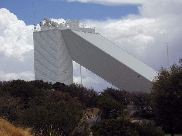
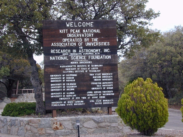
Once I entered Indian Country (N 32 03.5 W 111 23.9), it was little on vehicular traffic but big on visual scenery. I had gone about 11 miles into the Tohono Oĺodham Reservation when off to the left I see an exceptionally tall mountain peak with what looks to be a large white radar dome atop. I figure its some sort of military radar site. When I reach Az 386(N 32 01.624 W 111 34.655), the sign reads "KITT PEAK NATIONAL OBSERVATORY." This rings a bell in my slow moving brain. "Iĺve heard of this place and seen it on HBO." A one second decision to make a side trip, follows. Sign says 16 miles. I figure 30 min up. 30 min there. 30 min back to route. Iĺve got time. Me and Scoot Zuma off to the South.
The climb is gradual at first but progressively increases. Speed drops. 36mph 34, 30 as we get higher. Pass 4,000 ft elevation. Going gets slower. Making 25 mph now. Pass 5,000 ft. I catch a glimpse of what I think is a "Road Runner." This is the first of these critters Iĺve seen. Going gets slower as we wind around the mountain ridges. 23... 20..., 18..., 12 MPH. Come on Scoot. I know you can. I know you can. Scoot strains but keeps a slow, undaunting, steady pace. Zum, Zum, Zum, Scoot makes it past the 6,700 ft mark. The grade lessens, Scoot picks up speed. A steady 20mph. All right Scoot!! I knew you could. The scenery alone from this vista is worth the climb. Made a tour of the telescopes and very nice Visitor Center. Time to head back to SR 86.
We head down, no effort here. Scoot loves it. We start out slow. Pick up speed and speed and speed. Faster, faster, faster. The jagged rocks protruding from the mountain side whiz by in a blur. Down we go. The wind rushes by my face shield. Sounds like a hurricane. Curve after curve. I give Scoot the gas and let her do her thing. Break into the curve. Power out of the curve. Lean left. Lean right. Back to the left, right, left Breakneck speed as we zoom down the mountain . Oh! In the middle of the road is a two foot in diameter rock. Swerve to miss that. Curve left. Curve right. OK brain get me out of this insanity. I am outside the envelope of my experience and capabilities here. At this speed, if I was to go off the side of this mountain , Iĺd be airborne to San Diego and the "landing" would not be pretty. Besides, it would hurt. A LOT. I hit the air breaks and set a notch of flaps to slow to a fast but comfortable 40 MPH the rest of the way down. Itĺs on to Gila Bend and West to Yuma.
As I cross the land, I consistently scan the digital display of the $15 thermometer I bought at a Radio Shack in Tucson. Boy is it hot. Peaks out at 109.2F a few miles before I reach Gila Bend. Yuma is a welcome sight. I have no difficulty finding my Motel 6. A refreshing shower and crash for the night.