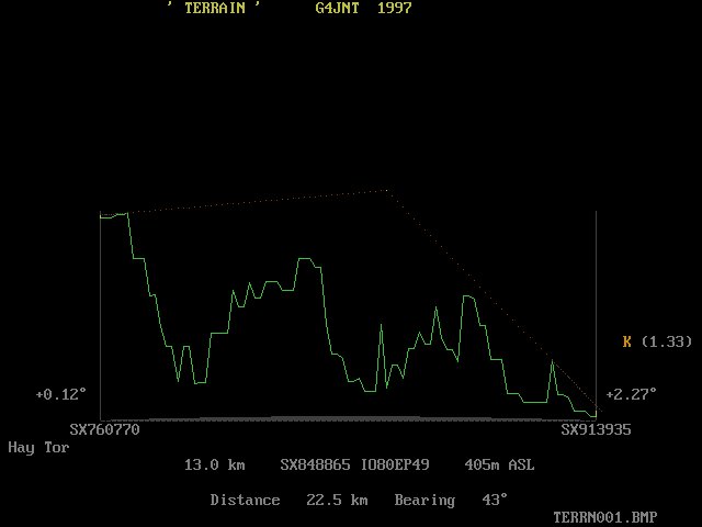
Plots the profile between two sites to show obstructions or visibility. The plot follows the form shown in the Microwave Handbook (Vol 1) where the curve of the Earths surface between the points is mapped to a parabola. Heights at any point between are drawn vertically, and a straight line between the two sites shows the visibility or otherwise.
The refractive index related K value for the effective Earths radio radius may be changed between spot values from 1 to 1.5 by pressing the K key whilst the plot is showing. The default value is the average 1.33 usually assumed, a K value of 1.0 represents (nearly) the optical sight path.
Sites may be entered as either NGR - eg SU499126, 8 digit Locator - eg IO90IV58 or by sitename, the format is recognised automatically. In the latter case the site database SITES.DAT is consulted to find the location. Whilst a six digit locator will be accepted, this will have a 55 added to place the reference at the centre of the square. Note that 6 digit locators are nowhere near accurate enough for height determination using this database.
When TERRAIN is called up as an individual program, mast heights need to be entered, these are taken from the site database if applicable, and in several cases this is important in getting over the next hill. TERRAIN may also be invoked by the mouse from several of the map plotting programs or by including the NGRs or Locators on the command line. In these cases no options for mast height are presented but a default height of 1m (a short person ?) is assumed in order to get over local ground to at least the next 500m point.
The mouse cursor allows heights at specific NGRs along the path to be read off. Clicking the left mouse button checks SITES.DAT for a site closer than 2km to the current cursor position.
Screenshot of TERRAIN.EXE:-