|
G3VGR
|
NECKARSTEIG Mosbach - Neckargerach
|
 It was raining when I left Mosbach. I crossed the Elz river and immediately started uphill to the Henschelberg via many steep switchbacks.
During the way up, there were good views back down towards Mosbach and the Elz valley.
I was now in a nature reserve and followed a fairly level forest road until reaching a steep descent back to suburbia at West Mosbach.
It had stopped raining and the day was now warm and humid. After coffee and purchase of brötchen for lunch at a baker's shop, the trail went back uphill very steeply.
I made slow progress as the path was very muddy and slippery (I would encounter these conditions for most of today's walk).
The wetness had enticed many large white snails to wander along the path, so I had to remain quite careful to avoid treading on them.
It was raining when I left Mosbach. I crossed the Elz river and immediately started uphill to the Henschelberg via many steep switchbacks.
During the way up, there were good views back down towards Mosbach and the Elz valley.
I was now in a nature reserve and followed a fairly level forest road until reaching a steep descent back to suburbia at West Mosbach.
It had stopped raining and the day was now warm and humid. After coffee and purchase of brötchen for lunch at a baker's shop, the trail went back uphill very steeply.
I made slow progress as the path was very muddy and slippery (I would encounter these conditions for most of today's walk).
The wetness had enticed many large white snails to wander along the path, so I had to remain quite careful to avoid treading on them.
At the top of the trail, I exited the woods next to a Bismarck Tower and crossed through a large glider field.
At Hamberg, the trail continued along a stretch of tarmac road (ugh) until I entered a wood of the Geo-Naturpark Bergstraße-Odenwald.
Most of the paths were very muddy and slippery, so progress was a little slow along the Schreckberg near Diedesheim, I also had the occasional view of the river on the south facing parts of the trail.
As yesterday, there were many bilingual information signs which enhanced the experience of walking through this ancient woodland.
Entering now into the denser Binau Forest, it was very pleasant to be walking along in dappled sunlight amongst the bright green spring foliage, accompanied by much birdsong, including the occasional woodpecker and cuckoo.
The map shows the Neckarsteig making an odd loop in the forest. Although I was originally doubtful of the reasoning for this, I followed the trail down to it anyway.
It was well worth the effort as this area was incredibly beautiful.
The whole loop was very damp which no doubt was the reason it was almost completely carpeted with wild garlic and the white of the flowers set against the green foliage was an incredible sight.
Reaching the end of the forest, there was a fine view across to Binau and the Neckartal.
Also visible near Binau was Germany's first nuclear power station (now decomissioned).
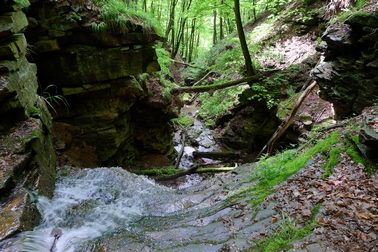
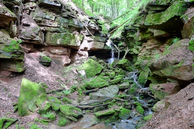
After another kilometre, I stopped for lunch outside a forester's hut then made my way back into more forest until I reached the top of the Margarethenschlucht
The whole ravine was incredibly muddy and very slippery.
Normally, it's best to ascend ravines when they are in this condition, but I had no choice.
However, steel ropes had been provided to assist through the difficult sections.
The Margerethenschlucht is quite beautiful and I stopped many times on the steep, treacherous descent to take photos.
I met quite a few people, mainly wearing inappropriate footwear and over-reliant on using the safety ropes, struggling to make their way up the gorge. I eventually reached a walker's hut at the end of the Margarethenschlucht and had a celebratory shot of Obstler from my hipflask.
From here, the trail followed a wide walled track along the cliff face overlooking the Neckar.
This continued for another 2Km until I reached the day's end at Neckargerach station.
I had a 50 minute wait for the hourly train, but there was a kneipe located conveniently opposite the platform, so I relaxed with a Hefeweizen until it was time to return to Mosbach.
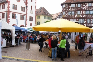
The Frühlingsfest in Mosbach had attracted many visitors, with much bratwurst and beer being consumed by the revellers
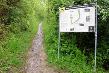
Path to Henschelberg
|
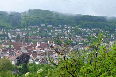
View back to Mosbach
|
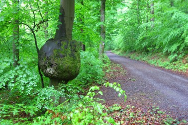
Along the Henschelbergweg
|

Mosbach glider field
|
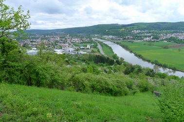
View to Diedesheim and Neckar
|

View to Binau and nuclear power station
|

White carpet
|

This way to Margarethenschlucht
|

Through the Margarethenschlucht
|
Through the Margarethenschlucht
|
Through the Margarethenschlucht
|

Through the Margarethenschlucht
|

View to Guttenbach on way to Neckargerach
|
Frühlingsfest in Mosbach Marktplatz
|
[Home]