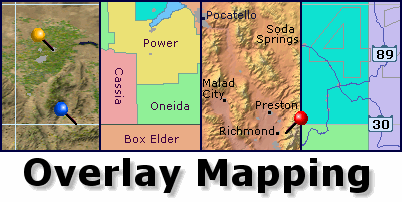
 What is Overlay Mapping ?
A common problem with any map, whether stored in printed form or on computer, is that there is either too little or too much information displayed. The mapmaker chooses what to put on the map. The client often wants different information. Overlay Mapping keeps everyone happy, by providing flexibility in the way a map is displayed, whilst displaying every item of data to its best advantage.
Overlay Mapping Advantages
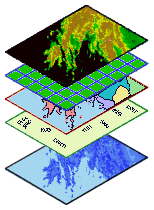 An Overlay Map has a number of layers or overlays that can be turned on and off as required. Not only can you choose how much information you want on the screen at any one time, you can also choose which order the layers are displayed in. Overlay Mapping thus gives you exciting new possibilities never available in a fixed or printed map. By comparing information on different layers, you can make new discoveries and find data inter-relationships only possible before with expensive GIS packages. An Overlay Map has a number of layers or overlays that can be turned on and off as required. Not only can you choose how much information you want on the screen at any one time, you can also choose which order the layers are displayed in. Overlay Mapping thus gives you exciting new possibilities never available in a fixed or printed map. By comparing information on different layers, you can make new discoveries and find data inter-relationships only possible before with expensive GIS packages.
Pre-Structured for Clarity
Each of the layers in an Overlay Mapper has been pre-aligned with others in the same map. This means that as you add more overlays to the map, you can still see the original data underneath. By careful choice of color, size, and transparency, every layer in the map helps you to learn something new about the scene you are looking at. The layers are all instantly available - no waiting for new data to load. No confusion with long lists of fonts, palettes, and symbol libraries. The map is ready when you are, and gets the job done.
Map Tools
The benefits don't stop there. Full positional details of the cursor are constantly available on the status bar in a variety of formats, together with distance and bearing information from your registered Home location. NAOMI, the North American Overlay Mapper, has full map-load-and-annotate capabilities, adding push pins from its data-base of 1000's of pre-programmed locations. You also have access to a large range of calculation and measurement tools, plus easy loading of satellite and weather maps.
Find out More
For more information, visit the following pages now:
- NAOMI - the North American Overlay Mapper
- GOM - the Global Overlay Mapper
|