Some screenshots of the Global Overlay Mapper in action. Note that the quality of the .jpg images are not as good as the standard GOM screen, due to format-coding limitations of the .jpg standard.
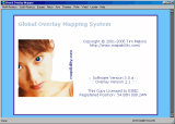
Full sized image: JPG PNG | The opening view of the Global Overlay Mapper. The version numbers and license information are clearly shown. Above is the main toolbar, used to select all of the Global Overlay Mapper's maps and functions. |
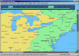
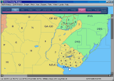
Full sized image: JPG PNG | A map is opened by clicking on the GOM main toolbar - this time its a sub-continental map of Eastern USA. Next, the blue toolbar over the map is used to select the required overlays to view: CQ Zones and Cities. |
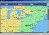
Full sized image: JPG PNG | The order in which the overlays are stacked depends on the order in which they are turned on. The top-most overlay is indicated by the colored bar beneath the overlay-buttons. Currently, the Grid Locator is on top. |
Full sized image: JPG PNG | A view of the Country overlay, with the Prefix overlay above it. Note how the administration area borders are seen below the prefix borders; this is useful in understanding the prefix area composition. |
Full sized image: JPG PNG | No background overlays are visible now; but the Latitude/Longitude grid clearly divides the map on view. The current cursor position is also shown in the Status Bar, to the bottom of the map, along with the Grid Locator value, and the distance/bearing from the location entered in your 'User Details'. |
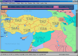
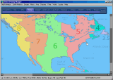
Full sized image: JPG PNG | Three overlays are visible here: CQ Zones, Country & Admin Area Names, and IOTA Reference Numbers. Note how one overlay does not mask another. Data is, as far as possible, given unique locations, for a clear and uncluttered map view; something not possible in most other Ham Map programs. |
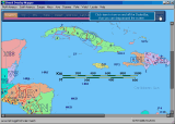
Full sized image: JPG PNG | A view of South America, showing parts of Argentina, Brazil, Paraguay, and Uruguay. The prefix maps in the Global Overlay Mapper are believed to be the most comprehensive currently available in any mapping package, and are fully updated with the latest values. |
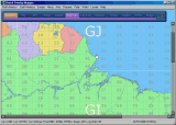
Full sized image: JPG PNG | Here, the 'Grid Locator' overlay has been turned on above the 'Country' overlay; an easy way of visualising the areas covered by the Grid Locator system. Note how the current position of the cursor is also identified on the Status Bar below, as 'GI19aa'. |
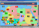
Full sized image: JPG PNG | This view shows some of the many country, state, and province flags included with the Global Overlay Mapper. This flag-set, which covers every DXCC entity, US and Australian state, and Canadian province, is also available in a pack for use on your own website - see here. |
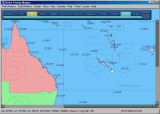
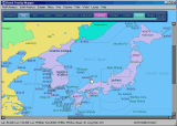
Full sized image: JPG PNG | A view of Eastern Australia, showing ITU Zones and IOTA Reference numbers - a useful resource for the IOTA contest operator and expeditioner. The Global Overlay Mapper is currently the only map suite showing IOTA positions in such detail. |
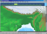
Full sized image: JPG PNG | A stunning view of the Relief overlay, showing the detail of Northern India and Nepal. The Relief images were generated from the GTOPO30 dataset. Individual 20° x 20° relief tiles are available for download on the MapAbility.com website. |
Full sized image: JPG PNG | This latest edition of the Global Overlay Mapper combines the previous Relief images with added Bathymetry, generated from the ETOPO2 dataset. Full details can be found in the Help & Information Guide. |
Full sized image: JPG PNG | This view shows the Time Zone overlay, and the time zones of North America. Time Zones are never as straight-forward as at first thought; the Global Overlay Mapper allows you to compare their position with every other data layer in the mapping-suite. |
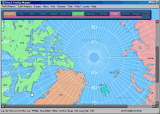
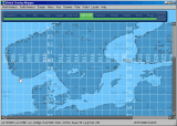
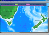
Full sized image: JPG PNG | One of the new maps in the latest version of the Global Overlay Mapper is an Arctic map, shown on the left. Other new maps include the Atlantic and Indian Oceans, and a World map. |
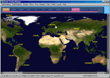
Full sized image: JPG PNG | Here is the new world map, showing an overlay created from Nasa's spectacular 'Blue Marble' image, a composite of Land Surface, Shallow Water, and Shaded Topography. It is the most detailed true-color image of the entire Earth to date. |
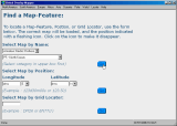
Full sized image: JPG PNG | Also available in the latest version is a 'Find' page. Choose a Prefix, Capital City, Country Name, Admin Area, Major City or IOTA Group, and it will be identified with a flashing icon on the correct map. |
Full sized image: JPG PNG | A click on the 'Scale' button turns on the Scalebar; useful for getting a rough idea of distance on the current map. The Scalebar can be dragged around the screen to where ever it is needed. |
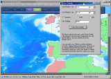
Full sized image: JPG PNG | Another new feature: You can edit your User Details of postion and callsign at any time. Once the program has been Registered you can also save these details between sessions. |
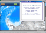
Full sized image: JPG PNG | A click on the 'About' button turns on the 'About' popup window, which contains information about the Global Overlay Mapping System, including Software Version, Overlay Version, Licensee Callsign, and Registered Position of your station. |