|
|
Coal Fields
Amateur Radio Association is an
amateur radio association for
facilitating emergency
communications throughout Southern
West Virginia and Eastern Kentucky
with the primary goal is hospital
linking, by working with existing
clubs and associations, individuals,
and existing systems in the area
with education, training, and
outreach programs.
First, let's take a few
moments to review why amateur
radio is so important for
emergency and disaster
communications.
During major disasters,
routine forms of communication,
such as public service
communications, the Internet,
cellular phones, and telephone
landlines, can quickly become
congested or even fail. While some
government agencies, but not all,
have access to other forms of
communication (satellite phones,
priority telephones, etc.) they,
too, can fail. Other government
agencies (local, county, state,
and regional), private citizens
and faith-based groups are often
left without any means of
communicating with each other or
the outside world.
An amateur radio network will allow
these entities to communicate at a
local, county, state, regional, and
worldwide level if a disaster knocks
out regular communications. Amateur
radio has more than often proven to
be the most successful emergency
communications tool when other forms
of communications are unavailable. |
"We
call them amateurs,
but, their skills level are
anything but amateur!" --
Walter Cronkite - KB2GSD - SK.
(1)
"These
are people in any other realm
would be called professionals."
-- Michael Ton - WT0N.
"They're the people who
know how to put the pieces
together, know how to build the
network, know how to get
information from one place to
another when every other systems
has failed. I don't think that's
Amateur." -- Michael Ton -
WT0N.
"Amateur Radio is the
only fail-safe
communication system in the
world. Amateur Radio is the best
backup communication system in
the world. And that's the way it
is!" - Walter Cronkite -
KB2GSD - SK. (1)
You can watch the you-tube
video yourself
at http://www.youtube.com/watch?v=5Z9136_Nhh4.
|
How ham radio
works in a disaster is
best summarized by the
following three
illustrations.
|
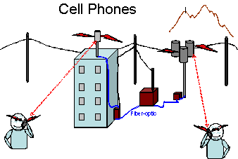
Most
people use cell
phone and
land-line
phones. These
phones depend
heavily on our
infrastructure
of communication
cables and
electrical power
distribution.
|
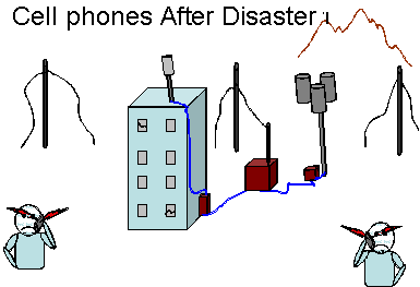
After
a disaster, the
communications
infrastructure may
be damaged. For
example, EMA
microwave systems,
public service
systems, cell
phone networks may
not work or could
be limited to
simple functions
such as text
messaging.
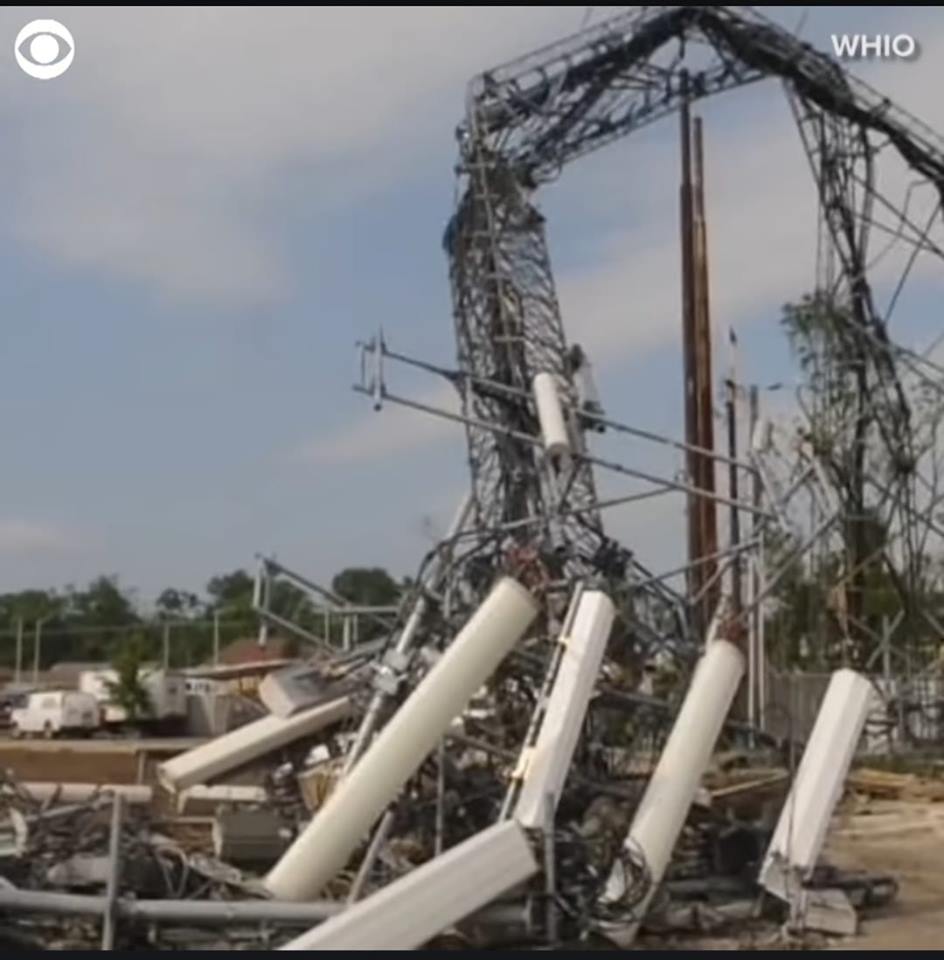
Here is
a real
communications
tower downed!
So
here is a good
picture for
anyone to use
next time
someone does
not understand
why we hams do
what we do in
this day or
cell phones.
This is a
local cell
tower (I-75 @
Wagner Ford
Road) just
north of
Downtown
Dayton Tuesday
morning. This
is what
happens to a
cell tower in
an EF3
tornado. [May
28, 2019]
|
|
|
Off
the grid
mountaintop
repeaters extend
the range of
hand-held and
mobile radios
hundreds of
miles. Since ham
radio repeaters
often have some
means of back-up
power, they will
usually continue
to function in
an emergency.
These repeaters
could be mobile
to go where
needed.
|
|
|
More about
Amateur Radio :
The following link is put out by the
ARRL. Watch it to learn some more. If
you have questions or quires, contact us
with the link near the bottom of this
page. https://www.youtube.com/watch?v=OExEEAFJ4oA
Licensing :
For
amateur radio, there is an
technician level test with 35
multiple-choice questions and a fee
of no more than $15.
Coal Fields Amateur Radio
Association will help to provide a
venue for classes and will work with
VEs and VECs.
More about licensing can be found at
W5YI.org
also at http://www.w5yi.org/page.php?id=17.
Training
:
Getting an amateur radio
license does not teach one how to
use a radio much. The amateur
radio operator, know as hams, test
mostly covers theory and
regulations. New radio operators
need mentoring or classes to
prepare them to be able to help in
an emergency. The emergency
co-ordinator at the Coal Fields
Amateur Radio Association center
developed a three-class program to
prepare newly licensed ham
operators to use the basic radio,
such as the Wouxun KG-UVD6P or the
Baofang UV5R+. Each class is two
to three hours and involves both
PowerPoint presentation and
hands-on training. This class
could be used at any center that
chooses to use the hand held
radios and mobile radios. The
PowerPoint slides are so thorough
that this presentation could be
presented remotely via webcast.
Interested members should contact
CFARA
for more details.
If
you are interested in helping the
region develop a radio network or
want to learn how to become a member
of the Coal Fields Amateur Radio
Association, please send your name
and contact information to CFARA.
We have assembled a committed group
of members who are available to
train other members in person as
well as over the Internet. No
experience is necessary, and all
ages are welcome.
The Plans :
At
this time the plans are to get
established legally with both
Kentucky and West Virginia, and, to
become a tax exempt entity via the
IRS.
Starting slowly with a repeater site
and getting the word out for those
whom wish to help us and have the
same drive and vision as we do.
As time goes on, the plans will be
increasing in coverage and training,
with medical centers and hospitals
joining with us in our venue. The
state and county EMAs and EOCs will
be involved as well.
For more information you may contact
CFARA
at any time via e-mail.
Thank you in advance for your
consideration to be a part of the
Coal Fields Amateur Radio
Association, and to those who
donated to our venue as well those
who will donate monies, equipment,
provisions for training and
meetings, and etc..
If you wish
to donate either monies
or equipment you can

And we do graciously appreciate
your help. |
|
Notes:
(1) To read more about Walter Leland
Cronkite, go to http://www.arrl.org/news/walter-cronkite-kb2gsd-sk.
Also http://en.wikipedia.org/wiki/Walter_Cronkite.
|
|
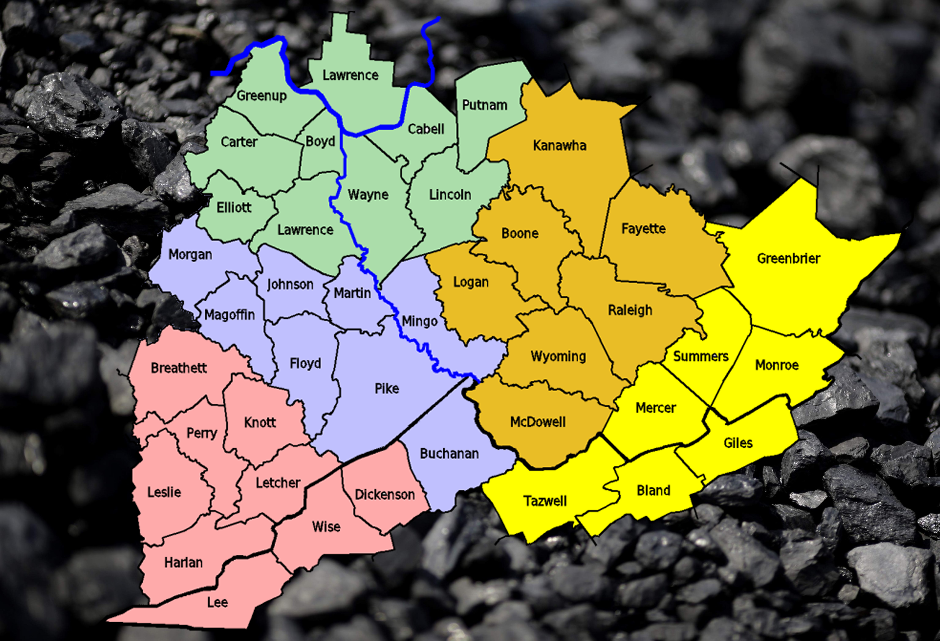
CFARA's coverage is widespread over 41 counties
of
the Coal Fields in the Appalachia.
This area is mostly in Kentucky and West
Virginia, but Ohio and Virginia borders as well.
Below the map are two tables, the left one is
sorted by District # and then the SAME #.
The right table is sorted by the state then
county (The SAME # is in order by default).
SAME (Specific Area Message Encoding) was
developed by
the National Weather Service for the Hazardous
Radio transmissions.
CFARA uses a 6 digit format that encompass the
SAME's 5 digit format for county/town Coding.
For the technical side of SAME for NWS's
purposes, go to : https://www.nws.noaa.gov/nwr/info/nwrsame.html.
|
CFARA Coverage
Map showing the Districts.
|
| Sorted by State then
County (CFARA #) |
| County |
State |
CFARA # |
District
# |
District
Name |
| Boyd |
Ky. |
021019 |
3 |
North |
| Breathitt |
Ky. |
021025 |
5 |
South West |
| Carter |
Ky. |
021043 |
3 |
North |
| Elliott |
Ky. |
021063 |
3 |
North |
| Floyd |
Ky. |
021071 |
4 |
West |
| Greenup |
Ky. |
021089 |
3 |
North |
| Harlan |
Ky. |
021095 |
5 |
South West |
| Johnson |
Ky. |
021115 |
4 |
West |
| Knott |
Ky. |
021119 |
5 |
South West |
| Lawrence |
Ky. |
021127 |
3 |
North |
| Leslie |
Ky. |
021131 |
5 |
South West |
| Letcher |
Ky. |
021133 |
5 |
South West |
| Magoffin |
Ky. |
021153 |
4 |
West |
| Martin |
Ky. |
021159 |
4 |
West |
| Morgan |
Ky. |
021175 |
4 |
West |
| Perry |
Ky. |
021193 |
5 |
South West |
| Pike |
Ky. |
021195 |
4 |
West |
| Lawrence |
Oh. |
039087 |
3 |
North |
| Bland |
Va. |
051021 |
1 |
South East |
| Buchanan |
Va. |
051027 |
4 |
West |
| Dickenson |
Va. |
051051 |
5 |
South West |
| Giles |
Va. |
051071 |
1 |
South East |
| Lee |
Va. |
051105 |
5 |
South West |
| Tazewell |
Va. |
051185 |
1 |
South East |
| Wise |
Va. |
051195 |
5 |
South West |
| Boone |
W. Va. |
054005 |
2 |
East |
| Cabell |
W. Va. |
054011 |
3 |
North |
| Fayette |
W. Va. |
054019 |
2 |
East |
| Greenbrier |
W. Va. |
054025 |
1 |
South East |
| Kanawha |
W. Va. |
054039 |
2 |
East |
| Lincoln |
W. Va. |
054043 |
3 |
North |
| Logan |
W. Va. |
054045 |
2 |
East |
| McDowell |
W. Va. |
054047 |
2 |
East |
| Mercer |
W. Va. |
054055 |
1 |
South East |
| Mingo |
W. Va. |
054059 |
4 |
West |
| Monroe |
W. Va. |
054063 |
1 |
South East |
| Putnam |
W. Va. |
054079 |
3 |
North |
| Raleigh |
W. Va. |
054081 |
2 |
East |
| Summers |
W. Va. |
054089 |
1 |
South East |
| Wayne |
W. Va. |
054099 |
3 |
North |
| Wyoming |
W. Va. |
054109 |
2 |
East |
|
| Sorted by District
then State |
| County |
State |
CFARA
# |
District # |
District Name |
| Bland |
Va. |
051021 |
1 |
South East |
| Giles |
Va. |
051071 |
1 |
South East |
| Tazewell |
Va. |
051185 |
1 |
South East |
| Greenbrier |
W. Va. |
054025 |
1 |
South East |
| Mercer |
W. Va. |
054055 |
1 |
South East |
| Monroe |
W. Va. |
054063 |
1 |
South East |
| Summers |
W. Va. |
054089 |
1 |
South East |
| Boone |
W. Va. |
054005 |
2 |
East |
| Fayette |
W. Va. |
054019 |
2 |
East |
| Kanawha |
W. Va. |
054039 |
2 |
East |
| Logan |
W. Va. |
054045 |
2 |
East |
| McDowell |
W. Va. |
054047 |
2 |
East |
| Raleigh |
W. Va. |
054081 |
2 |
East |
| Wyoming |
W. Va. |
054109 |
2 |
East |
| Boyd |
Ky. |
021019 |
3 |
North |
| Carter |
Ky. |
021043 |
3 |
North |
| Elliott |
Ky. |
021063 |
3 |
North |
| Greenup |
Ky. |
021089 |
3 |
North |
| Lawrence |
Ky. |
021127 |
3 |
North |
| Lawrence |
Oh. |
039087 |
3 |
North |
| Cabell |
W. Va. |
054011 |
3 |
North |
| Lincoln |
W. Va. |
054043 |
3 |
North |
| Putnam |
W. Va. |
054079 |
3 |
North |
| Wayne |
W. Va. |
054099 |
3 |
North |
| Floyd |
Ky. |
021071 |
4 |
West |
| Johnson |
Ky. |
021115 |
4 |
West |
| Magoffin |
Ky. |
021153 |
4 |
West |
| Martin |
Ky. |
021159 |
4 |
West |
| Morgan |
Ky. |
021175 |
4 |
West |
| Pike |
Ky. |
021195 |
4 |
West |
| Buchanan |
Va. |
051027 |
4 |
West |
| Mingo |
W. Va. |
054059 |
4 |
West |
| Breathitt |
Ky. |
021025 |
5 |
South West |
| Harlan |
Ky. |
021095 |
5 |
South West |
| Knott |
Ky. |
021119 |
5 |
South West |
| Leslie |
Ky. |
021131 |
5 |
South West |
| Letcher |
Ky. |
021133 |
5 |
South West |
| Perry |
Ky. |
021193 |
5 |
South West |
| Dickenson |
Va. |
051051 |
5 |
South West |
| Lee |
Va. |
051105 |
5 |
South West |
| Wise |
Va. |
051195 |
5 |
South West |
|
|
This Table, below, is not
complete for the data survey is not
finished.
| Calculated
Tower Sites in the Counties within
CFARA |
| Col
# |
Expiation
of Column Cell Colors
|
| Zone |
These
colors matches with those in the above
tables. |
1
|
Total
Number of all Sites Calculated for
that county. - Subject to change.
|
2
|
Number of Sites
Planned/Engineering. See Sites Menu
for listing. |
3
|
Number
of Sites Under Construction
|
4
|
Number
of Sites Constructed and under test
|
5
|
Number
of Sites Partely Operational
|
6
|
Number
of Sites Fully Operational
|
7
|
Number
of Federal or State EMAs/EOCs sites
|
8
|
Number
of County EMAs/EOCs & VFDs
|
9
|
Number of Hospitals in
County |
10
|
Special
- See, if any, notes at the bottom of
the table below. |
| SAME # |
County |
ST |
Noteses |
Zonee |
1
|
2
|
3
|
4
|
5
|
6
|
7
|
8
|
9
|
10
|
| 021019 |
Boyd |
KY |
-
|
3
|
- |
- |
- |
- |
- |
- |
- |
- |
- |
- |
| 021025 |
Breathitt |
KY |
-
|
5
|
- |
- |
- |
- |
- |
- |
- |
- |
- |
- |
| 021043 |
Carter |
KY |
-
|
3
|
- |
- |
- |
- |
- |
- |
- |
- |
- |
- |
| 021063 |
Elliott |
KY |
-
|
3
|
- |
- |
- |
- |
- |
- |
- |
- |
- |
- |
| 021071 |
Floyd |
KY |
Beginning County
|
4
|
10
|
1 |
1 |
1 |
1 |
0 |
1 |
1 |
3 |
1 |
| 021089 |
Greenup |
KY |
-
|
3
|
- |
- |
- |
- |
- |
- |
- |
- |
- |
- |
| 021095 |
Harlan |
KY |
-
|
5
|
- |
- |
- |
- |
- |
- |
- |
- |
- |
- |
| 021115 |
Johnson |
KY |
-
|
4
|
3
|
2 |
0 |
0 |
0 |
0 |
0 |
2 |
1 |
- |
| 021119 |
Knott |
KY |
-
|
5
|
- |
- |
- |
- |
- |
- |
- |
- |
- |
- |
| 021127 |
Lawrence |
KY |
-
|
3
|
- |
- |
- |
- |
- |
- |
- |
- |
- |
- |
| 021131 |
Leslie |
KY |
-
|
5
|
- |
- |
- |
- |
- |
- |
- |
- |
- |
- |
| 021133 |
Letcher |
KY |
-
|
5
|
- |
- |
- |
- |
- |
- |
- |
- |
- |
- |
| 021153 |
Magoffin |
KY |
-
|
4
|
2
|
0
|
0
|
0 |
0 |
0 |
0 |
1 |
0 |
- |
| 021159 |
Martin |
KY |
-
|
4
|
- |
- |
- |
- |
- |
- |
- |
- |
- |
- |
| 021175 |
Morgan |
KY |
-
|
4
|
- |
- |
- |
- |
- |
- |
- |
- |
- |
- |
| 021193 |
Perry |
KY |
-
|
5
|
- |
- |
- |
- |
- |
- |
- |
- |
- |
- |
| 021195 |
Pike |
KY |
Second County for CFARA
|
4
|
5 |
0 |
0
|
0
|
0
|
0
|
1
|
2
|
1
|
- |
| 039087 |
Lawrence |
OH
|
-
|
3
|
- |
- |
- |
- |
- |
- |
- |
- |
- |
- |
| 051021 |
Bland |
VA |
-
|
1
|
- |
- |
- |
- |
- |
- |
- |
- |
- |
- |
| 051027 |
Buchanan |
VA |
-
|
4
|
- |
- |
- |
- |
- |
- |
- |
- |
- |
- |
| 051051 |
Dickenson |
VA |
-
|
5
|
- |
- |
- |
- |
- |
- |
- |
- |
- |
- |
| 051071 |
Giles |
VA |
-
|
1
|
- |
- |
- |
- |
- |
- |
- |
- |
- |
- |
| 051105 |
Lee |
VA |
-
|
5
|
- |
- |
- |
- |
- |
- |
- |
- |
- |
- |
| 051185 |
Tazewell |
VA |
-
|
1
|
- |
- |
- |
- |
- |
- |
- |
- |
- |
- |
| 051195 |
Wise |
VA |
-
|
5
|
- |
- |
- |
- |
- |
- |
- |
- |
- |
- |
| 054005 |
Boone |
WV |
-
|
2
|
- |
- |
- |
- |
- |
- |
- |
- |
- |
- |
| 054011 |
Cabell |
WV |
-
|
3
|
- |
- |
- |
- |
- |
- |
- |
- |
- |
- |
| 054019 |
Fayette |
WV |
-
|
2
|
- |
- |
- |
- |
- |
- |
- |
- |
- |
- |
| 054025 |
Greenbrier |
WV |
-
|
1
|
- |
- |
- |
- |
- |
- |
- |
- |
- |
- |
| 054039 |
Kanawha |
WV |
-
|
2
|
- |
- |
- |
- |
- |
- |
- |
- |
- |
- |
| 054043 |
Lincoln |
WV |
-
|
3
|
- |
- |
- |
- |
- |
- |
- |
- |
- |
- |
| 054045 |
Logan |
WV |
-
|
2
|
- |
- |
- |
- |
- |
- |
- |
- |
- |
- |
| 054047 |
Mc
Dowell |
WV |
-
|
2
|
- |
- |
- |
- |
- |
- |
- |
- |
- |
- |
| 054055 |
Mercer |
WV |
-
|
1
|
- |
- |
- |
- |
- |
- |
- |
- |
- |
- |
| 054059 |
Mingo |
WV |
Third County in CFARA
|
4
|
3
|
3
|
0 |
0 |
0 |
0 |
0
|
1
|
1
|
- |
| 054063 |
Monroe |
WV |
-
|
1
|
- |
- |
- |
- |
- |
- |
- |
- |
- |
- |
| 054079 |
Putnam |
WV |
-
|
3
|
- |
- |
- |
- |
- |
- |
- |
- |
- |
- |
| 054081 |
Raleigh |
WV |
-
|
2
|
6 |
- |
0 |
0 |
1 |
0 |
1 |
5
|
3 |
- |
| 054089 |
Summers |
WV |
-
|
1
|
- |
- |
- |
- |
- |
- |
- |
- |
- |
- |
| 054099 |
Wayne |
WV |
-
|
3
|
- |
- |
- |
- |
- |
- |
- |
- |
- |
- |
| 054109 |
Wyoming |
WV |
-
|
2 |
- |
- |
- |
- |
- |
- |
- |
- |
- |
- |
About #
|
Note :
|
021071
|
021071-0010 CnC
- Testing Center
|
|
|
|
|
|
|
|
|