|
|
BANDAS
MODOS / BANDS MODES
|
- 160, 80, 40, 20, 17, 15, 12 and 10 mtr.
- SSB
| CA6TBB
Gladys Ormeño (YL)
|
|
| CE6NE
Mario Aranguiz

|
(Other
Call: CE6OMY – CE6NES) Amateur radio since 1985
Awards:County
Award (CQ – U.S.A. Counties)
765 Counties First Endos. Nr 3.091
Comunas Zona 12 ( All ) Nr 96 – Chile
AJD (All Japan Districts Award – Nr 8469
WAC (IARU – All Continents)
WAS (All USA States)
172 Countries (DXCC) confirmed ( Not Requested )
Contest:All
Asian DX Contest (Phone) First Chile 1999
All Asian DX Contest (Phone) First Chile 2000
WWDX Contest SSB 21 Mhz SSB Low (Actually Record Zone 12) - 1997
International Contest Award – I.A.R.U. - Phone 1997 10 mtrs. First
Chile - 1997
International Contest Award – I.A.R.U. – Phone single low power
- All -
First Chile 1998
WW – WPX – Contest – First in Chile SSB 21 MHz
WAG – Single Op. All Band - CW – First Chile
www.qsl.net/ce6ne
|
| CE6AMN
Carlos Montesinos |
Dxpedition:
1993 XR6M SA061 |
| CE6AKH
Jaime Herrera
|
Dxpedition:
1993 XR6M SA061
|
| CE6TBN
Marco A. Quijada

|
Menber
of: NCDXF, INDEXA
Dxepeditions: CE0Z SA-005 jan.2000, CE6TBN/7 SA-018 Sep.
2000 CE6TBN/7 SA-018 Oct. 2001, CE6TBN/7 SA-018 and SA-043 March
2002, CE6TBN/p SA-061 August 2002 CE0Z SA-005 October 2002
(CQWW)
Award: IOTA 100, AJD, WACE
www.qsl.net/ce6tbn
|
|
|
|
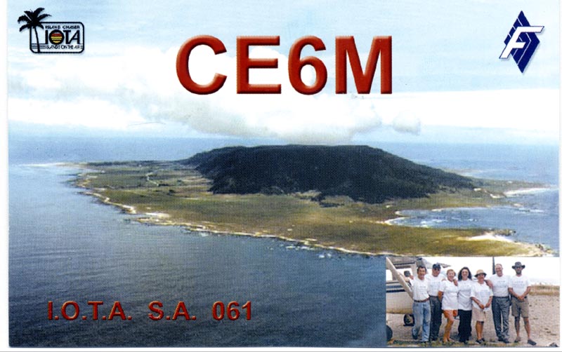
LOCATION
Mocha Island is located just
off of the chilean coast, 34 kilometers from Tirúa Village, between
the BíoBío and Araucanía Regions (8th and 9th Regions). Its exact geographical
location is 38°23'06'' south latitude and 73°52'00'' west longitude.
The main characteristic of the island is its oval shape. A mountain
in the centre of the island reaches 300 meters high. The mountain is
covered by an almost impenetrable native forest with arrayanes (luma
apiculata), ulmos (eucryphia cordifolia), olivillos (aextoxicon punctatum),
laurel or tihue (laurelia zempervirens) and a great variety of ferns.
This rich virgin forest is the ideal habitat for birds like "pidenes"
(chilean bird similar to a coot), woodpigeon, "bandurrias" (a kind of
stork) and the famous pinkfooted shearwater. It is also the home of
the famous autochthonic mamal called "pudu" (small deer of Chile).
Just south of the island, there are several rock formations protruding
from the sea, a copious marine fauna can be found. To photograph the
amazing place where sea lions abound would be the best testimony of
your visit to this paradisiacal site. White beaches, with average temperatures
of 18°- 20° C make this an ideal place for performing sports like fishing,
sailing, windsurf, snorkeling or just to gather small rocks of different
colours and shapes, precious shells of several kind of small marine
animals, petrified shells and a few curious artifacts from things like
"Santiago", ship which wrecked during 60's
ACCESS TO THE ISLAND
Since 1990 the island has had an excellent and fast
air transportation to the continent. There are two landing strips. The
first one is private. It belongs to the author of this web site and
it is 735 meters long. The second one, is 1,200 meters and belongs to
Dirección de Aeropuertos de Chile (chilean airports manager's office).
With this kind of infraestructure a Cessna 172 reaches the island in
one hour from the Carriel Sur Airport in Concepción. Moreover, it is
only 12 minutes from the excellent asphalt air strip in Tirúa Village
on the mainland of Chile.
( source www.isla-mocha.cl
)
|
|