December 8, 2001
Hi Class,
We had quite an experience that I want to tell you about. Our entire group flew on a helicopter to a number of sites where we will be making measurements with our airborne laser sensor. We initially began boarding the helicopter around 07:00 on Friday night. There were a total of 9 of us on the helicopter so we were really packed in pretty tightly. As you can see, we were dressed in our cold weather clothing and wore flight helmets. Riding on the helicopter is like riding on a super elevator. The helicopter first starts to go almost straight up, but it soon starts to move forward as well as upward. Once we reached about 1,000 feet, we flew along at about 100 miles per hour.
Our initial goal was to find a reasonably flat site that we could fly over every day with the airborne laser system to check its accuracy. We had two places to check. The first site, called Marble Point, was on an point of land located about 20 minutes from our base at McMurdo. On the way we passed several huge icebergs that the pilot said were about 100 feet high. We landed at Marble Point and checked it out. As you can see, it wasn't too flat and there were many loose rocks laying about. We decided that this area was not suited for checking our accuracy.
We next flew to a frozen lake, Lake Thomas, where we were hoping the ice was relatively flat. On the way, we passed some pretty vistas (views) including view_1 and view_2. We found Lake Thomas to be relatively flat with some rough areas. The lake is larger than it looks on this photo. You can see some of our group on the far side if you look closely. Can you see them? They are over one-half mile away. We found that Lake Thomas would be suited for checking the accuracy of our airborne laser.
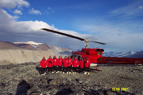
With the selection of a site for checking our sensor behind us, we decided next to look at some of the valleys that we would be surveying over the next month. We next flew to a vantage point called the Dais overlooking Wright Valley. From there we got some spectacular views such as view_1, view_2. and view_3. As we approached Wright Valley we were able to see views of the valley wall as well as views into the valley and down the valley. From the Dais, you can also see the ice falls located in the background behind me on this photo. Before we left the Dais, we asked the pilot to take a group photo with the helicopter in the background. When we left the Dais, we flew closer to the ice falls and got an even better view.
We next flew toward Beacon Valley which will be one of our most important survey areas. On the way we saw the upper part of the Taylor Glacier and noted interesting banding in the rock formations and a beautiful valley adjacent to Finger Mountain. The reason for studying Beacon Valley is to look closely at the polygons that form in the valley. The polygons form due to repeated cycles of freezing and thawing. The polygons looked small from high altitude but were visible because of the snow that was lying in the depressions along the edges of the polygons. The polygons gradually became more distinct as we dropped in altitude. After we landed we were able to examine the polygons closely on foot. As you can see in the photo, the individual polygons are made of rocks and earth materials. They measure about 60 feet across and are about 3 to 5 feet in height. We should be able to measure them very well with our scanning laser system.
After leaving Beacon Valley we needed to get more fuel so we dropped in on a fuel cache (pile of 55 gallon drums of jet fuel) located near the top of Round Mountain. There the pilot pumped two drums of fuel into the helicopter and we took off for our final destination overlooking Taylor Valley. Taylor Valley is the site we plan to survey first. On route to Taylor Valley we passed over an area where the glacier was highly crevassed (deeply cracked) due to movement of the ice. We landed on top of the canyon wall overlooking Taylor Valley and the Taylor Glacier where you can see our helicopter setting. That vantage point gave us great views of the lower and upper parts of the Taylor Valley and some glaciers that empty into the valley. A view over the canyon rim provided a view of the ice camp below. Some of the research buildings can be seen on the frozen lake while the remaining buildings are on the shoreline of the lake.
The canyon overlooking Taylor Valley would be our final landing in the Dry Valleys that night. We flew down the Taylor Valley and continued back to the base at McMurdo. On the way we passed by the blue ice runway where we had landed the week before on our C-130 flight from New Zealand. The runways and parking ramp glimmered in the fading sunlight of the early morning 03:00 AM as we passed. Three C- 130 aircraft can be seen on the parking ramp ready for use later in the morning. We landed shortly thereafter and retired for the night. Mission successfully completed, we all felt fairly exhausted.
Best Regards,
Robert Swift